Library Catalog
Latest Documents and Publications listed. Use search terms in the box below to find what you need
Status of River Breakages Along Juba and Shabelle Rivers - Issued August 2024
The Food and Agriculture Organization’s Somalia Water and Land Information Management (FAO SWALIM) Project, has finalized the analysis and mapping of the river breakages along the Juba and Shabelle rivers using very high resolution satellite imagery. Breakages identified in the map have been classified into five categories; Open, Overflow, Canal Breakage and Canal Intake Flooding and Closed with sandbags. A legend/Key for further explanation of the different types of breakages is provided.
A long the Shabelle river, a total of 171 Open points, 2 Canal Breakages, 51 Canal flooding points, 323 Overflow points and 17 points closed with sandbags have been identified while 104 Open points, 1 Canal Breakage, 16 Canal flooding points, 83 Overflow points and 1 point closed with sandbags have been identified. Several other points, which are either potential or temporarily closed with sandbags, have also been identified. There is a need to close the open points and reinforce areas where there are weak river embankments to avoid loss of lives and livelihoods during the upcoming Deyr season.
Publication Type:
Map
Publication Date:
Author:
Corporate Author:
Shabelle River Level and Flood Risk Update-Issued - 24 August 2024
This flood advisory is applicable to Hirshabelle – Belet Weyne, Bulo Burte, Jalalaqsi, Jowhar, Balcad districts and the surrounding areas.
Even with the absence of rains in Somalia and eastern parts of Ethiopia, the continued downflow of water from the upper catchments in central portions of Ethiopian Highlands has led to a sustained rise in the levels along the Shabelle river. Due to the distance of flow, the river system has taken more than a month to respond to the rains observed in the central parts of Ethiopian Highlands.
After the river level at Belet Weyne steadily dropped from the bankful level (8.30 m) on 24 May 2024, a slow upward trend began on 11 July 2024. The river level consistently rose thereafter but relatively stable and below the moderate flood risk level in July, and only crossing the moderate flood risk level on 8 August 2024. In the last 48 hours, the river at Belet Weyne has approached its critical zone with today’s level being 10 cm above high flood risk threshold (7.30 m) posing high risk of flooding. This signals a need for close monitoring and potential flood preparedness particularly at vulnerable breakage points.
As expected, a similar pattern has been observed downstream at Bulo Burte where the river level began a consistent rise from a low of 2.63 m on 14 July 2024 to 6.52 m today (24 August 2024) which is 2 cm above moderate flood risk level (6.50 m). About the same time (13 July 2024), the level at Jowhar also observed a steady rise which has however been stable in the last week with today’s level being 22 cm below moderate flood risk level (5.00 m). The reported flood episodes at Jowhar and Balcad are therefore occasioned by river breakages and not overbank spillage. Nonetheless, the floods at Balcad are reported to have affected 27 villages with approximately 10,000 people in need of emergency relief in terms of shelter, WASH, health and nutrition support.
Considering the lag-effect of the observed rains in central parts of Ethiopian Highlands in the last one month and the light rains to dry conditions forecast over the catchment in both Somalia and Ethiopia, the river levels are expected to rise further but not to bankful levels in the coming week.
There is therefore an EMERGING HIGH RIVERINE FLOODING RISK AT BELET WEYNE and MODERATE RIVERINE FLOODING RISK DOWNSTREAM AT BULO BURTE, and low overbank flooding risk downstream at Jalalaqsi, Jowhar and Balcad, but continued episodes of breakage driven flooding at Jowhar and Balcad.
Publication Type:
Flood Alert
Publication Date:
Author:
Corporate Author:
Rainfall Forecast for SIRA II project Area – Issued 03 June 2024
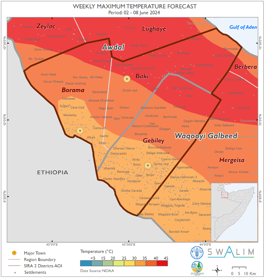
This week marks the end of the Gu rains across the project area, ushering in the Hagaa season. The forecasted dry conditions may benefit agropastoral activities such as weeding in the Awdal region, which includes Baki and Borama districts. Here, above-normal Hagaa conditions are expected to maintain soil moisture, supporting continued crop and fodder production. However, the anticipated hot and dry air mass over the northern parts of the project area this coming week may lead to severe evapotranspiration, posing significant challenges to agropastoral activities. As we transition into the Hagaa season, it is crucial to implement measures for water conservation and the preservation of existing crops and fodder.
Publication Type:
Rainfall Forecast
Publication Date:
Author:
Corporate Author:
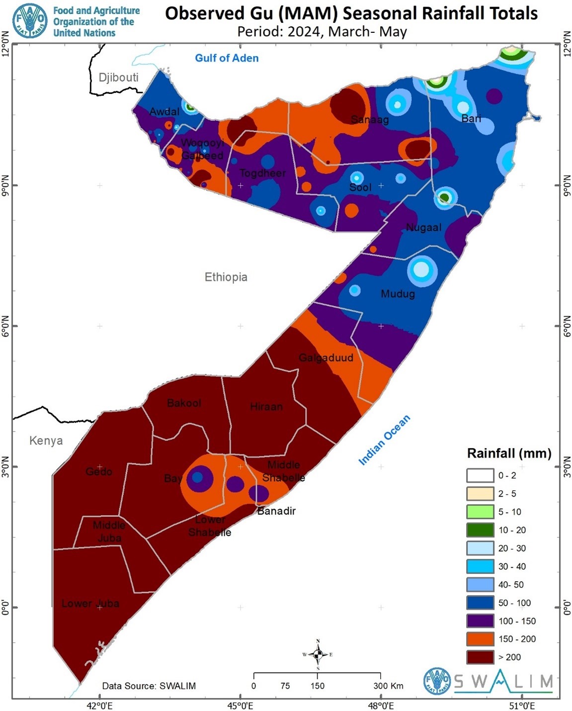
Somalia Gu 2024 Rainfall Performance Review and Impacts on Livelihood - Issued 20 June 2024
Several key findings have been obtained following a review of the 2024 Gu (March-April-May) rains and forecast of Hagaa (June-July-August) season:
The heaviest cumulative rainfall was observed in Hiraan region (408.2 mm at Belet Weyne) and Woqooyi Galbeed region (477.0 mm at Gumburaha station); with the least rainfall observed over Puntland.
There was more than 3 weeks-long dry spell in all the stations in the country with even longer than two months over some stations in Puntland.
The earliest rains (in March) of equal or more than 20 mm per day was observed in some stations in Somaliland with no single station in South and Central Somalia and Puntland that received daily rains of such intensity in the same month.
Based on the adopted definition of onset, there was a staggered start to the rainy season across the stations with the earliest onset observed in Qansadhere in Bay region on March 24, 2024, and the latest onset in Gacan-libaah in Togdheer region on May 3, 2024.
Over the Juba and Shabelle River Catchments, the above normal rains were evenly spread with less consecutive rainy days and therefore moderate flood magnitude. However, the close to double the LTM rains observed at Doolow (117.5 mm) on 07-May-24, and the more than double the average rainfall at Belet Weyne resulted in to floods, displacing 7,100 families in Belet Weyne town.
On a positive note, the rains observed in Gu across most other parts of the country were beneficial to agropastoral livelihoods in many aspects including favorable soil moisture conditions for crop and fodder production, and replenishment of surface and ground water sources. The more than a month-long dry spell within the season however posed a serious threat to the survival of crops and water retention in both open, shallow and groundwater sources.
According to IGAD Climate Prediction and Application Centre (ICPAC), wetter than usual conditions are expected over few areas in north-western and southern coastal parts of the country with rest of the country remaining usually dry over the Hagaa season.
According to Climate Prediction Centre (CPC), there is a 65 % chance that the present ENSO-neutral conditions will favor the development of La Niña later in July-September. Depending on the evolution of other drivers including the Indian Ocean Dipole (IOD), this may drive below normal Deyr 2024 conditions over Somalia.
The below normal rainfall conditions associated with the even better likelihood (85 %) of La Niña persisting into November-December-January may trigger a multi-season drought with a potential reversal of the currently achieved agropastoral gains.
This bulletin presents both qualitative and quantitative review of the temporal and spatial variation of the observed, and verification of the forecast Gu rainfall amount and anomaly, length of wet and dry spells, and onset dates. It also reviews the experienced (Gu) and current (Hagaa) and long term projected (Deyr) weather impacts on livelihoods over Somalia.
Publication Type:
Rainfall Performance
Publication Date:
Author:
Corporate Author:
Somalia Rainfall Forecast – Issued 22 May 2024
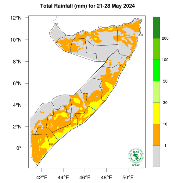
According to ICPAC, during the week between 21 and 28 May 2024, dry conditions and light rainfall is expected in most inland parts of the country with chances of moderate rains over coastal parts of the southern regions. These forecast coastal rains seem to be driven by the warming in the Indian Ocean.
As the Inter Tropical Convergence Zone (ITCZ) shifts further north, its impact on the Gu rains across the country begins to diminish ushering in Hagaa season. However, given that today’s Madden Julian Oscillation’s (MJO) 3-day forecast position is associated with better skill and reliability, there is still some likelihood of moderate rains before the end of the month. Day-to-day monitoring is therefore advised.
The temporal and spatial distribution of the forecast rainfall (Map 1) is as follows:
Light cumulative rainfall of less than 50 mm is forecast over most coastal parts of Somalia including; Berbera district in Woqooyi Galbeed region; northern parts of Ceel Afweyn, Ceerigaabo and Laasqoray districts in Sanaag region; Bossaso, Qandala, Banderbeyla, Caluula and Iskushuban districts in Bari region; Eyl district in Nugaal region; Jariiban, Xarardheere and Hobyo districts in Mudug region; Ceel Dheer in Galgaduud region; Adan Yabaal, Cadale and Balcad districts in Middle Shabelle region; Afgooye, Qoryooley, Kurtunwaarey and Sablaale districts in Lower Shabelle region; Mogadishu in Banadir region; Jilib district in Middle Juba region; Jamaame, Kismayo and Badhaadhe districts in Lower Juba region. Similarly, other inland districts that are likely to receive light rainfall include Hargeisa and Gebiley districts in Woqooyi Galbeed region; Odweyne district in Togdheer region; Belet Weyne district in Hiraan region; Tayeeglow district in Bakool region; Baydhaba and Qansax Dheere districts in Bay region; and Afmadow district in Lower Juba region.
Dry conditions (including rainfall less than 1 mm) are likely in most areas of Awdal and Sool regions; Burao district in Togdheer region; southern parts of Ceel Afweyn and Ceerigaabo districts in Sanaag region; Qardho district in Bari region; Garowe district in Nugaal region; western parts of Burtinle distric in Nugaal region; Gaalkacyo and Galdogob districts in Mudug region; Caabudwaaq and western parts of Cadaado district in Galgaduud region; Ceel Barde, Xudur, Rab Dhuure and Waajid districts in Bakool region; Doolow, Belet Xaawo and Ceel Waaq districts in Gedo region; and Caluula district in Bari region.
Tropical Storm Ialy Advisory
Tropical Storm Ialy (Map 2) started off as a Disturbance on 14 May 2024 growing into a Moderate Tropical Storm on 16 May and into a Severe Tropical Storm on 19 May. It is forecast to reduce in intensity in the next 24 hours as it approaches the Equator to just a normal low-pressure system without making landfall in any part of the East African coastline. However, the area of influence may stretch towards the Equator resulting in strong surface wind, large ocean waves and moderate rainfall over the coastal and nearby inland areas of Badhaade, Kismaayo and Jilib Districts.
Publication Type:
Rainfall Forecast
Publication Date:
Author:
Corporate Author:
Somalia Rainfall Forecast – Issued 29 May 2024
Weekly Rainfall Forecast:
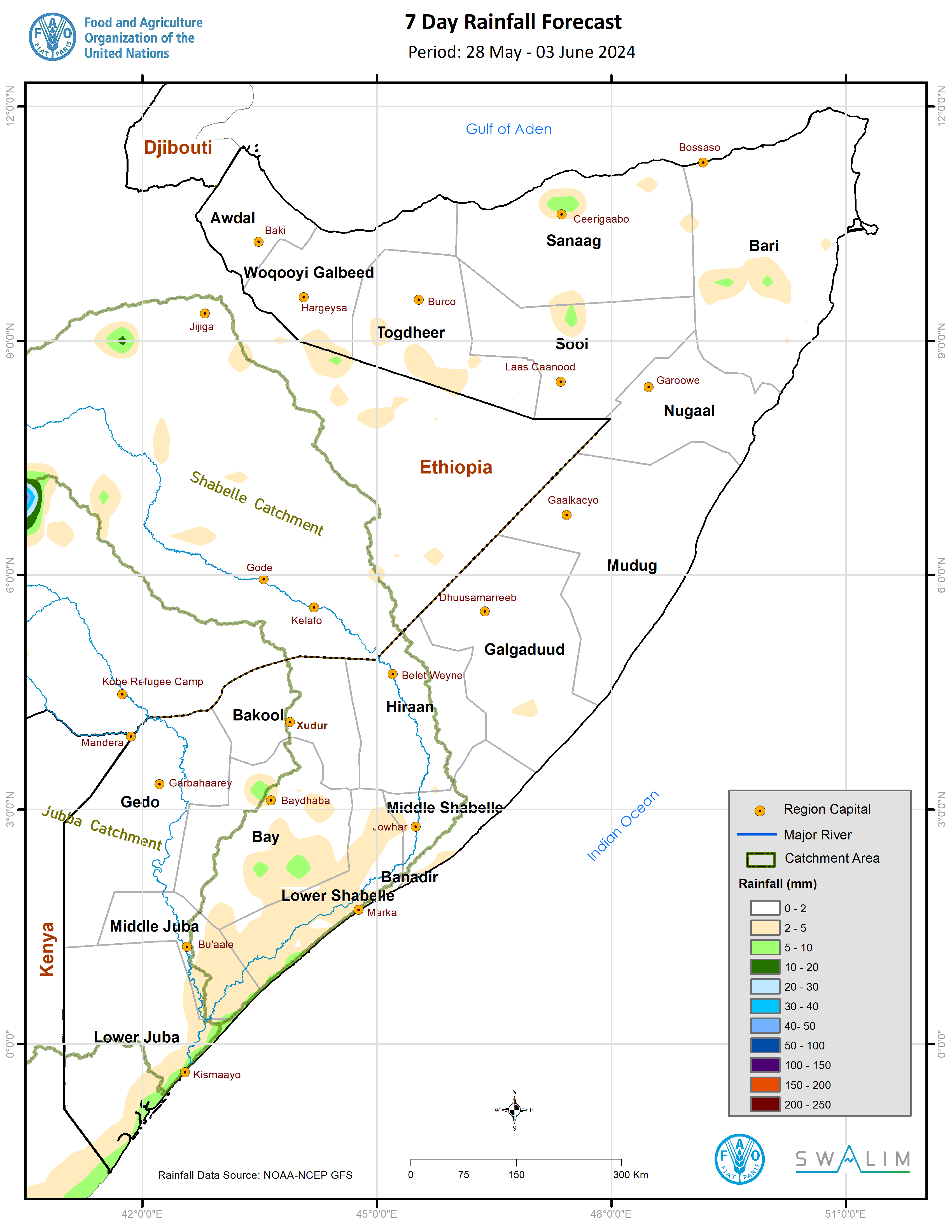
According to ICPAC, during the week between 28 May to 3 June 2024, dry conditions are expected in most inland parts of the country with chances of light rainfall over coastal parts of the southern regions (Map 1). Given that this forecast week represents the transition out of the Gu season, it is important to mention that, according to ICPAC, above-normal Hagaa rainfall conditions are expected over Lower Juba, Middle Juba, Lower Shabelle, and Awdal regions. On the other hand, Togdheer and Sool-Sanaag regions are likely to experience drier-than-normal Hagaa conditions.
Evolution of Rainfall Drivers:
As the Inter Tropical Convergence Zone (ITCZ) shifts further north, its impact on the Gu rains across the country begins to diminish ushering in Hagaa season. As the ITCZ shifts further north, a low-pressure system will be set up in Indian Sub-continent triggering the Southwest monsoon winds. As the winds blow from land into the Ocean (westerly land breeze) between 3:00 am and 9:00 am in the morning they converge with the prevailing easterly winds aiding lifting of warm and moist air causing the morning showers observed and forecast over the coastal parts of southern regions including Banadir. The forecast shift in the position of Madden Julian Oscillation’s (MJO) index from the Indian Ocean re-affirms the forecast dry conditions inland and a reduction in the intensity of the morning coastal showers in the coming days. This shift is also likely to lead to a reduction in the cyclonic activity in the southwestern Indian Ocean and favor such disturbances in the northern Indian Ocean particularly Bay of Bengal.
Publication Type:
Publication Date:
Author:
Corporate Author:
Somalia Rainfall Forecast – Issued 02 May 2024
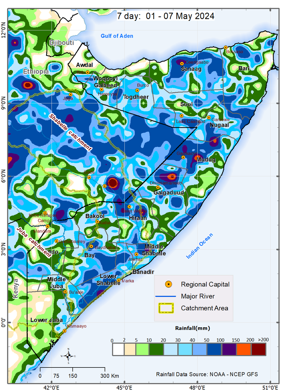
During the week between 1 and 7 May 2024, and based on NOAA-NCEP GFS, light to moderate rain is expected over most parts of the country, with chances of heavy rain and flash floods expected in some areas of Hiraan, Galgaduud and Mudug regions. Based on climatology, the observed and anticipated northward spread of the rains into the central and northern parts of Somalia is favored by the northward movement of the Inter Tropical Convergence Zone (ITCZ). The arrival of the ITCZ will attract low-level incursions of precipitable water inland thereby mitigating the prolonged dry conditions over Bari.
The Madden Julian Oscillation (MJO) index, which ideally is expected to propagate eastwards covering the entire globe in 40 – 60 days, and therefore anticipated to be present over 1 of the 8 regions for about one week, has stagnated over the eastern Indian Ocean for about two weeks. This is favoring the observed moderate to heavy rains in Somalia and the extremely heavy rains elsewhere within the Greater Horn of Africa (GHA). The location of the index since 25 April shows improvement in strength and increase in forecast skill and reliability. As of 1 May, the index is at region 4 and is forecast to be back to region 2 within the next two weeks. Its lagged effect favors a continuation of moderate rains in the first half of the forecast period (1 – 4 May) with expected possible resumption of heavy rainfall activity in the second week of May. The favorable effect of the Indian Ocean Dipole (IOD) on the rains cannot also be ruled out. According to Australian Bureau of Meteorology, the warming in the Indian Ocean indicates a likelihood of positive IOD developing earlier than usual.
Although Somalia is not within the direct path of the current tropical disturbance in the western Indian Ocean, the low pressure associated with it may lead to sucking of moisture causing generally less rainfall over the southern part of the country. Week by week and day-to-day monitoring is therefore advised.
The temporal and spatial distribution of the forecast rainfall (Map 1) are as follows:
• Very heavy cumulative rainfall between 150 mm and 200 mm is likely over some isolated areas in central and eastern parts of Dhuusamareeb district in Galgaduud region, northern parts of Hobyo district, southern parts of Gaalkacyo district, northern parts of Jaariban district in Mudug region, and southern parts of Belet Weyne district in Hiraan region. The rains over isolated areas in the above places particularly in the central and eastern parts of Dhuusamareeb district may be very intense leading to more than 200 mm in cumulative terms and are likely to fall between 1 and 3 May 2024 with likelihood of flash flooding in vulnerable spots including flat and crowded human settlements.
• Heavy cumulative rainfall between 100 mm and 150 mm is likely over the rest of the other areas in the following places: central and eastern parts of Dhuusamareeb district in Galgaduud region, northern parts of Hobyo district, southern parts of Gaalkacyo district, northern parts of Jaariban district, and eastern parts of Galdogob district in Mudug region, and western and southern parts of Belet Weyne district in Hiraan region. Similarly heavy rains are likely over northern parts of Ceerigaabo district in Sanaag region, southern parts of Burtinle district in Nugaal region, eastern parts of Jowhar district in Middle Shabelle region and Baraawe district in Lower Shabelle.
• Moderate cumulative rainfall between 50 mm and 100 mm is likely over the rest of the areas in Dhuusamareeb district, and eastern parts of both Ceel Buur and Ceel Dheer districts in Galgaduud region, Gaalkacyo and Galdogob district and coastal parts of Xaradheere district in Mudug region, and Belet Weyne district and northern parts of Bulo Burte district in Hiraan region, northern parts of both Ceerigaabo and Laas Qoray districts in Sanaag region, Burtinle district and northern parts of Eyl district in Nugaal region, Jowhar district in Middle Shabelle region, Baraawe, Sablaale, Kurtunwaarey and Wanla Weyne districts in Lower Shabelle region. Similar rains are likely over Qandala district and southern parts of both Qardho and Bandarbeyla districts in Bari region, central parts of Hargeisa-Odweyne districts’ border, Buhoodle district in Togdherregion, Las Anod and Xudun-Taleex districts’ border in Sool region. Rains of similarly moderate intensy are likely over some areas in South West State including Buur Hakaba district and central parts of Baydhaba district in Bay region, central parts of Bakool region and central parts of Bardheere district in Gedo region.
• Light cumulative rainfall of less than 50 mm is forecast over most of the following regions: Lower Juba, Middle Juba, Bay, Bakool, Gedo, Togdheer, Woqooyi Galbeed, Bari, Nugaal, coastal parts of Mudug, southern parts of Sanaag, central parts of Sool, and southern parts of Awdal.
• Dry conditions are likely to prevail over southwestern, northwestern, and northeastern parts of the country. These include western parts of Afmadow district in Lower Juba region, Zeylac and Lughaye districts in Awdal region, Berbera district in Woqooyi Galbeed region, Caluul and Iskushuban districts in Bari region.
Publication Type:
Rainfall Forecast
Publication Date:
Author:
Corporate Author:
Somalia Rainfall Forecast – Issued 09 May 2024
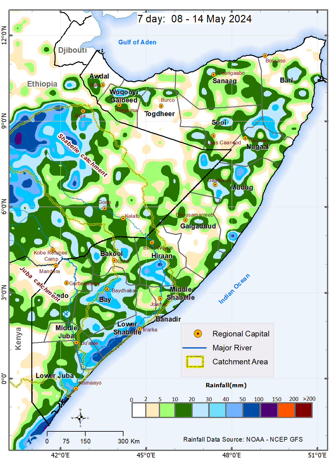
During the week between 8 and 14 May 2024, and based on NOAA-NCEP GFS, light rains are expected over most parts of the country with moderate rains likely over Lower Shabelle and coastal parts of Lower Juba. Based on climatology, the observed and anticipated northward spread of the rains into the central and northern parts of Somalia is favored by the northward movement of the Inter Tropical Convergence Zone (ITCZ). The ITCZ's arrival will attract low-level incursions of precipitable water inland, mitigating prolonged dry conditions over Bari.
After the prolonged stagnation, the Madden Julian Oscillation (MJO) index has now propagated eastwards from our region. This is likely to favor a week-long break from the moderate to heavy rains received in the region. The forecast return of the index is likely to drive moderate to heavy rains from 15 May 2024. The forecast rains in the third week of May (15 – 21 May) are associated with better skill and reliability. The rains are likely to decrease thereafter marking the end of the Gu season particularly in Jubaland, South West and Hirshabelle. The effect of the sea surface temperature (SSTs) difference between the eastern and western Indian Ocean on the rains cannot also be ruled out. According to Australian Bureau of Meteorology, the warming in the Indian Ocean indicates a likelihood of positive Indian Ocean Dipole (IOD) developing earlier than usual. However, it has been reported that MJO events occurring during positive IOD have weaker convection and less organized wind anomalies which restricts local low-level moisture transport thus explaining the low likelihood of very extreme rainfall this season. Week by week and day-to-day monitoring is therefore advised.
The temporal and spatial distribution of the forecast rainfall according to NOAA-NCEP GFS are as follows:
• Moderate cumulative rainfall between 50 mm and 100 mm is likely over Lower Shabelle region particularly Barawe, Marka and southern parts of both Sablaale and Kurtunwaarey districts. Similar moderate rains are likely over the coastal parts of Lower Juba region particularly Badhadhe, Kismaayo and Jamaame districts. The rains, according to ICPAC weekly forecast may be more intense (100 mm to 200 mm) over Hirshabelle region including the Shabelle River catchment within the country and upstream in Ethiopia.
• Light cumulative rainfall of less than 50 mm is forecast across the most other parts of the country particularly in Woqooyi Galbeed, Sanaag, Nugaal, Mudug, Hirshabelle, Bay, Bakool, Middle Shabelle, and Middle Juba regions.
• Dry conditions are particularly likely over the Zeylac, Lughaye and Baki districts in Awdal region; Berbera district and eastern parts of Hargeisa district in Waqooyi Galbeed region; Odweine, Burao and Buhoodle districts in Togdheer region; Ceel Afweyn district in Sanaag region; and Bossaso, Qandala, Calula, Isku-shuban and Bandarbeyle districts in Bari region. Towards the central part of the country dry conditions are also expected over western parts of both Burtinle and Garowe and coastal parts of Eyl district in Nugaal region; Xarardheere, Hobyo and Jariiban districts in Mudug region; and Ceel Buur and Cadaado districts in Galgaduud region. Dry conditions are also expected western parts of Afmadow district in Lower Juba region; Doolow and Belet Xaawo districts, western parts of both Luuq and Garbahaarey districts and southern parts of Baardheere district in Gedo region; Saakow district in Middle Shabelle region; Xudur in Bakool region; Wanla Weyn district in Lower Shabelle region; and western parts of Jowhar district in Middle Shabelle region.
Publication Type:
Rainfall Forecast
Publication Date:
Author:
Corporate Author:
Somalia Rainfall Forecast – Issued 14 May 2024
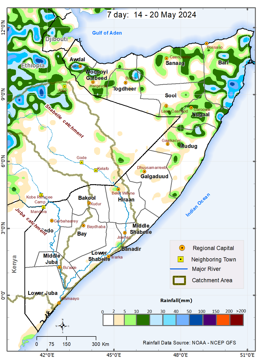
According to NOAA-NCEP GFS, during the week between 14 and 20 May 2024, light to moderate rain are expected in Puntland and Somaliland with dry conditions likely throughout central and southern parts of the country. This general northward spread of the rains is favored by the northward presence of the Inter Tropical Convergence Zone (ITCZ).
As had been anticipated, the eastward propagation of the Madden Julian Oscillation (MJO) index from the Indian Ocean favored the general dry conditions during the last week (7 – 13). While the index is presently within the region, none of the weather forecast models has captured its effect on rainfall during this forecast week. Given that its 5-day forecast position is associated with better skill and reliability, there is still a likelihood of moderate to heavy rains towards the end of the forecast week i.e., from around 18 May 2024. Day-to-day monitoring is therefore advised. The rains are likely to decrease thereafter marking the end of the Gu season particularly in Jubaland, Southwest and Hirshabelle.
The temporal and spatial distribution of the forecast rainfall are as follows:
Moderate cumulative rainfall between 50 mm and 100 mm is likely over northwestern parts of Bandarbeyla district in Bari region. These rains are likely to be received between 14 and 16 May 2024.
Light cumulative rainfall of less than 50 mm is forecast over several areas in both Bandarbeyla and Iskushuban districts, northern parts of Qardho district, and southern parts of both Qandala and Caluula districts in Bari region; Garowe district, coastal parts of Eyl district, and northern parts of Burtinle district in Nugaal region; eastern and western parts of Ceerigaabo district, western parts of Ceel Afweyn district, and northern parts of Laasqoray district in Sanaag region; southern parts of Laas Caanod district and northern parts of Caynabo district in Sool region; northern parts of Burco district and western parts of Owdweyne district in Togdheer region; Gebiley district and northern and southern parts of Hargeysa district, and southern parts of Berbera district in Woqooyi Galbeed; and Borama and central and southern parts of Baki district, northern parts of Zeylac district in Awdal region. Rains of similarly trace amounts are also likely over isolated areas of Hobyo district, northern parts of Jariiban district, eastern parts of Gaalkacyo district in Mudug region; western parts of Dhuusamarreeb district in Galgaduud region; Belet Weyne town in Hiraan region; eastern parts of Afgooye district in Lower Shabelle region; and Banadir region.
Dry conditions (rainfall less than 1 mm) are likely in most areas in the following regions: Lower Juba, Middle Juba, Gedo, Bay, Bakool and Middle Shabelle region. Dry conditions are also likely to prevail over Sablaale, Baraawe, Kurunwaarey, Qoryooley, Wanla Weyn districts and central and western parts of Afgooye district in Lower Shabelle region; Jalalaqsi, Bulo Burte and most other parts of Belet Weyne district in Hiraan region; Ceel Dheer, Ceel Buur, Cabudwaaq and Cadaado districts and most other parts of Dhuusamarreeb district in Galgaduud regiuon; Xarardheere district, vast areas of Hobyo district, most other parts of both Jariiban and Gaalkacyo districts in Mudug region. Towards the northern parts of the country, dry conditions are also likely over inland parts of Eyl district, and most other parts of Burtinle district in Nugaal region; Bossaso district, most other parts of Qardho, Qandala and Caluula districts in Bari region; most other parts of Ceerigaabo, Laasqoray and Ceel Afweyn district in Sanaag region; Xudun, Taleex, and most other parts of both Laas Caanood and Caynabo districts in Sool region; Buhoodle and Sheikh districts and most other parts of Burco and Owdweyne districts in Togdheer region; central parts of Hargeysa district, and most other parts of Berbera district in Woqooyi Galbeed; and Lughaye, northern parts of Baki district, and southern parts of Zeylac district in Awdal region.
Publication Type:
Rainfall Forecast
Publication Date:
Author:
Corporate Author:
Tropical Storm Ialy Advisory - English - Issued 21 May 2024
This Tropical Storm Advisory is applicable to Lower Juba and Middle Juba regions, particularly Badhaadhe, Kismaayo and Jilib Districts and the surrounding areas where moderate localized rains, strong winds and large ocean waves may be observed.
Tropical Storm Ialy started off as a Disturbance on 14 May 2024 growing into a Moderate Tropical Storm on 16 May and into a Severe Tropical Storm on 19 May. It is forecast to reduce in intensity in the next 36 hours (about 1 and a half days) as it approaches the Equator to a just a normal low-pressure system without making landfall in any part of the East African coastline. However, the area of influence may stretch beyond the Equator resulting in strong surface wind, large ocean waves and moderate rainfall over the coastal and nearby inland areas of Badhaahde, Kismaayo and Jilib Districts.
Therefore, a MODERATE-RISK WARNING FOR STRONG WINDS, LARGE OCEAN WAVES AND FLASH FLOODS is in effect for Badhaahde, Kismaayo and Jilib Districts and the surrounding areas due to spillover effects of Tropical Storm Ialy.
Publication Type:
Storm Alert
Publication Date:
Author:
Corporate Author:
Pages
 RSS feed [compliant with the Agris AP] |
  Agris AP XML


